CloudCompare Update List Message
From:
"CloudCompare Update List" <cloudcompare@PROTECTED>
Date:
October 25th 2017
 Dear CloudCompare
enthusiasts,
A new version has been released. You'll find it here:
|
|
|
|||||||
 Windows 64 bits Windows 64 bits |
 |
 |
 |
||||||
 Windows 64 bits Stereo (support for NVidia 3D Vision and Oculus Rift) Windows 64 bits Stereo (support for NVidia 3D Vision and Oculus Rift) |
 |
 |
 |
||||||
 Mac OS 64 bits Mac OS 64 bits |
Thanks
to Andy Maloney, MacOS apps are available here |
||||||||
 Linux 64 bits Linux 64 bits |
Thanks to Romain Janvier, packages for Ubuntu/Debian will be availablevery soon (stay tuned ;) | ||||||||
 Sources Sources |
git
repository: https://github.com/cloudcompar/cloudcompare (for compilation instructions, refer to the BUILD.md file) |
||||||||
Your support
is greatly appreciated. Many thanks to all our supporters who made
donations on pledgie!


The 2.9 Omnia version is finally ready!
Yes, we've nicknamed it again (this time it's Omnia)
Once again, many new things in this release:
- qCompass: an impressive new plugin for interpretation and analysis of virtual outcrop models (by Sam Thiele, Monash Univ., Australia)
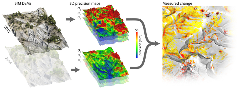
- new 'Precision Maps' variant of the M3C2 plugin (by Michael James and his colleagues
from Lancaster Univ., UK)
- improved contour lines generation thanks to GDAL
- option to transfer (and
interpolate) a scalar field from one entity to the other
- automatic detection of the center of rotation (can be deactivated ;)
- and as always, many more improvements and bug fixes
Your support is really appreciated!
Our 'Fairness' campaign has been quite successful, and we wish to thanks all those who have contributed so far. For those who have missed it, we just want to remind to our users that CloudCompare is not "free". It's true that downloading and using CloudCompare can be done freely and free of charge... but developping and maintaining it is certainly not free! Open source projects can't live without active support from the community.
Here are the new features:
- New plugin: qCompass (structural geology toolbox) [Windows, macOS]
- for the interpretation and analysis of virtual outcrop models
- Map Mode, for delineating geological units
- Compass Mode for measuring orientations and thicknesses
- refer to the wiki page of the plugin
- Thanks to
Sam Thiele (Monash Univ., Australia) for this great contribution!
- 3D view pivot management
- new option to position the
pivot point automatically on the point currently at the screen center
(dynamic update)
(it's now the default behavior > it can be toggledon and off thanks to the dedicated icon in the 'Viewing tools' toolbar or the 'Shift + P' shortcut) - double clicking on the 3D view will also reposition the pivot point on the point under the cursor
- the state of this option is
automatically saved and restored when CC starts
- New tool to import scalar fields from one cloud to another: 'Edit > SFs > Interpolate from another entity'
- 3 spatial interpolation methods are supported: nearest neighbor, inside a sphere or with a given number of neighbors
- 3 algorithms are available: average, median and weighted average
- see the wiki documentation
- (can be useful to import a scalar field on a higher resolution cloud or on a mesh reconstructed by qPoissonRecon for instance)
- New interactor to change the default line width (via the 'hot zone' in the upper-left corner of 3D views)

- New sub-menu 'Tools > Batch export'
- 'Export cloud(s) info' (formerly in the 'Sand-box' sub-menu)
- exports various pieces of information about selected clouds in a CSV file:
- name, point count, barycenter
- + for each scalar field: name, mean value, std. dev. and sum
- 'Export plane(s) info'
- exports various pieces of information about selected planes in a CSV file:
- name, width, height, center, normal, dip and dip direction
- New option: 'Display > Show cursor coordinates'
- if activated, the position of the mouse cursor relatively to the 3D view is constantly displayed
- the 2D position (in pixels)
is always displayed and he 3D position of the point below the cursor is
displayed if possible
- New shortcuts to change the rotation center:
- 'P' key
- double-click (ona point cloud
or a mesh)
And here below is the (huge) list of improvements
- When a picking operation is active, the ESC key will cancel it.
- qBroom plugin now has a wiki documentation
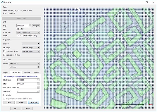
- Rasterize tool
- Contour lines generation is now based on GDAL (more robust, proper handling of empty cells, etc.)
- new option to re-project contour lines computed on a scalar field (i.e. a layer other than the altitudes) on the altitudes layer
- the grid step bounds have been widened (between 1E-5 and 1E+5)

- qAnimation plugin
- new output option 'zoom' (contrarily to the existing 'super resolution' option, this one actually scales the output video dimension)
- glitch fix: the plugin
doesn't spam the Console at each frame if the 'super resolution' option
is > 1 anymore
- M3C2 plugin
- "Precision Maps" support added (see M3C2 plugin wiki documentation)
- Allows for the computation of the uncertainty based on precision scalar fields (standard deviation along X, Y and Z) instead of the cloud local roughness

- 'Unroll' tool:
- new cone 'unroll' mode (the true 'unroll' mode - the other one has been renamed 'Straightened cone')
- option to export the deviation scalar-field (deviation to the theoretical cylinder / cone)
- dialog parameters are now saved in persistent settings

- LAS files
- the 'Spatial Reference System' of LAS files is now stored as meta-data and restored when exporting the cloud as a LAS/LAZ file.
- LAS 1.3+ support [Windows ony]:
- the qLAS_FWF plugin (based on LASlib) can now load most of the standard LAS fields
- the plugin can now save files (with or without waveforms)
- the plugin can now be called in command line mode:
- FWF_O: open a LAS 1.3+ file
- FWF_SAVE_CLOUDS: save cloud(s) to LAS 1.3+ file(s) (options are 'ALL_AT_ONCE' and 'COMPRESSED' to save LAZ files instead of LAS)
- reminder: when loading a LAS
1.3+ file, one must select the 'LAS
1.3 or 1.4 (*.las,*.laz)' filter in
the file loading dialog
- New method: 'Edit > Waveforms > Compress FWF data':
- To compress FWF data associated to a cloud (useful after a manual segmentation for instance as the FWF data is shared between clouds and remains complete by default)
- Compression is done automatically when saving a cloud with the 'LAS 1.3 / 1.4' filter (see above) but it's not done when saving the entity as a BIN file
- PLY files
- quads are now supported (they will be loaded as 2 triangles)
- DXF files
- now based on dxflib 3.17.0
- point clouds can now be exported to DXF (the number of points should remain very limited)
- see fixed bugs below
- Edit > SF > Compute Stat. params:
- the RMS of the active scalar field is now automatically
computed and displayed in the Console
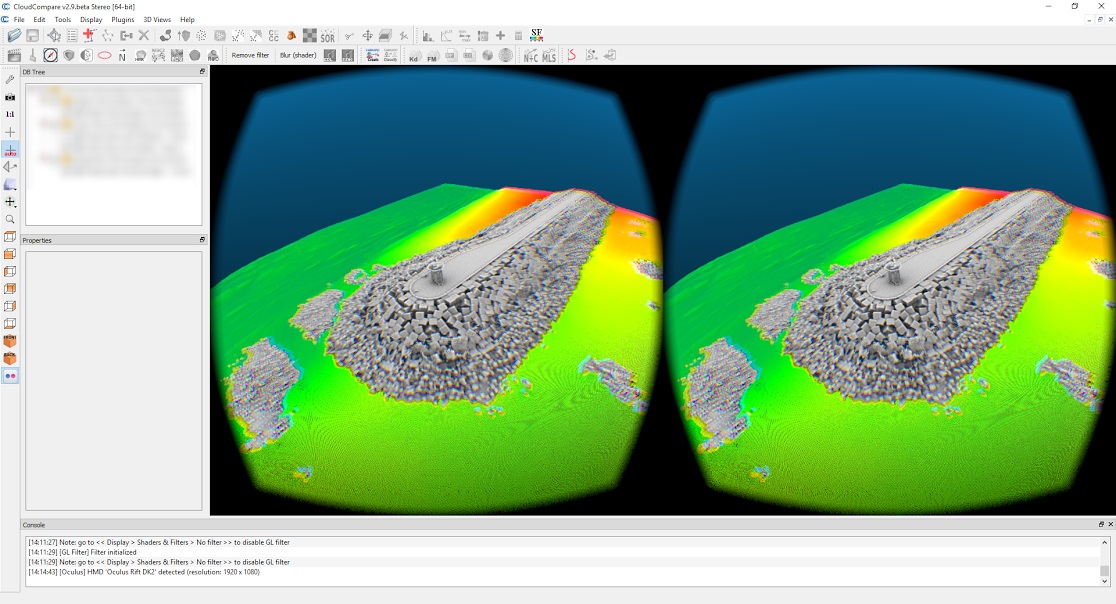
- Oculus support
- CC now displays in the current 3D view the mirror image of what is displayed in the headset
- using SDK 1.15

- Point List Picking tool
- the list can now be exported as a 'global index, x, y, z' text file
- Scale / Multiply dialog:
- new option to use the same scale for all dimensions
- new option to apply the scale to the 'Global shift' (or not)
- New Menu Entry: 'Edit > Grid > Delete scan grids'
- Deletes the scan grids associated to a point cloud (typically loaded from FARO or DP files)
- (allows to save a lot of space when exporting the cloud to a
BIN file (if you don't use the scan grid)
- qEllipser plugin:
- option to export the image as a (scaled) point cloud
- see tutorial here: https://www.youtube.com/watch?v=mX27Euym9es
- Normal computation tool:
- new algorithm to compute the normals based on scan grids (faster, and more robust)
- the 'kernel size' parameter is replaced by 'the minimum angle of triangles' used in the internal triangulation process
- Plane
and Quadric modes will now automatically increase the radius adaptively
to reach a minimum number of points and to avoid creating 'zero'
(invalid) normals
- Edit the scalar value of a single point
- create a label on the point (SHIFT + click)
- make sure a scalar field is active
- right click on the label entry in the DB tree and select 'Edit scalar value'
- Merge (clouds)
- new option to generate a scalar field with the index of the original cloud for each point
- Command line mode:
- the Rasterize tool is now accessible via the command line:
- '-RASTERIZE -GRID_STEP
{value}'
- additional options are:
- -VERT_DIR {0=X/1=Y/2=Z} - default is Z
- -EMPTY_FILL {MIN_H/MAX_H/CUSTOM_H/INTERP} - default is 'leave cells empty'
- -CUSTOM_HEIGHT {value} - to define the custom height filling value if the 'CUSTOM_H' strategy is used (see above)
- -PROJ {MIN/AVG/MAX} - default is AVG (average)
- -SF_PROJ {MIN/AVG/MAX} - default is AVG (average)
- -OUTPUT_CLOUD - to output the result as a cloud (default if no other output format is defined)
- -OUTPUT_MESH - to output the result as a mesh
- -OUTPUT_RASTER_Z - to output the result as a geotiff raster (altitudes + all SFs by default, no RGB)
- -OUTPUT_RASTER_RGB - to output the result as a geotiff raster (RGB)
- -RESAMPLE - to resample the input cloud instead of generating a regular cloud (or mesh)
- if OUTPUT_CLOUD and/or OUTPUT_MESH options are selected, the resulting entities are kept in memory.
- Moreover if OUTPUT_CLOUD is selected, the resulting raster will replace the original cloud.
- 2.5D Volume Calculation tool
- '-VOLUME -GRID_STEP {...} etc.' (see the wiki for more details)
- Export coord. to SF
- '-COORD_TO_SF {X, Y or Z}'
- Compute unstructured cloud normals:
- '-OCTREE_NORMALS {radius}'
- for now the local model is 'Height Function' and no default orientation is specified
- Clear normals
- '-CLEAR_NORMALS'
- New mesh merging option
- '-MERGE_MESHES'
- Compute mesh volume:
- '-MESH_VOLUME'
- optional argument: '-TO_FILE {filename}' to output the volume(s) in a file
- LAS files:
- when loading LAS files without any specification about Global Shift, no shift will be applied, not even the LAS file internal 'shift' (to avoid confusions)
- however, it is highly
recommanded to always specifiy a Global Shift (AUTO or a specific vector) to avoid
losing precision when dealing with big coordinates!
- Other improvements:
- the progress bar shouldn't appear anymore when loading / saving a file with 'SILENT' mode enabled
- the ASCII loading dialog shouldn't appear anymore in 'SILENT' mode (only if CC really can't guess anything)
- the default
timestamp resolution has been increased (with milliseconds) in order to
avoid overwriting files when saving very small file (too quickly!)
- Plugins can now be called in command line mode:
- the 'ccPluginInterface::registerCommands' method must be reimplemented
- someone still needs to do the job for each plugin ;)
- Other
- color scales are now listed in alphabetical order (in the entity options)
- polylines exported from the 'Interactive Segmentation' tool will now use the same Global Shift as the segmented entity(ies)
- when changing the dip and dip direction of plane parallel with XY, the resulting plane shouldn't rotate in an arbitrary way anymore
- the OpenGL filters and single-button plugin toolbars are now on the right side of the window by default (to reset to the default layouts, use "Reset all GUI element positions" at the bottom of the Display menu)
- the Plane edition dialog now lest the user specify the normal plane in addition to its dip and dip direction
- new 'Clone' icon with a colored background so as to more clearly spot when the icon is enabled (Nyan sheep!)
- qPoissonRecon: now based on PoissonRecon 9.011
- the default maximum point size and maximum line width increased to 16 pixels
And last but not least, here are the bug fixes:
- STL files are now output by default in BINARY mode in command line mode (no more annoying dialog)
- when computing distances, the octree could be modified but the LOD structure was not updated (resulting in potentially heavy display artifacts)
- glitch fix: the 'SF > Gradient' tool was mistakenly renaming the input scalar field ('.gradient' appended)
- glitch fix: the picking process was ignoring the fact that meshes could be displayed in wireframe mode (they are now ignored in this case)
- command line 'CROSS_SECTION' option: the repetition of the cuts (<RepeatDim> option) could be incomplete in some cases (some chunks were missing)
- raster loading: rasters loaded as clouds were shifted of half a pixel
- the 'Edit > Sensors > Camera > Create' function was broken (input parameters were ignored)
- merging clouds with FWF data would duplicate the waveforms of the first one
- invalid lines in ASCII (text) files could be considered as a valid point with coordinates (0, 0, 0)
- Point-pair based alignment tool:
- extracting spheres on a cloud with Global Shift would create the sphere in the global coordinate system instead of the local one (i.e. the sphere was not visible)
- deleting a point would remove all the detected spheres
- The FARO I/O plugin was associating a wrong transformation to the scan grids, resulting in weird results when computing normals or constructing a mesh based on scan grids
- When editing only the dip / dip direction of a plane, the rotation was not made about the plane center
- qSRA plugin: profile polyline automatically generated from cylinders or cone were shifted (half of the cylinder/cone height), resulting in a 'shifted' distance map (half of the cloud was 'ignored')
- DXF export
- the I/O filter was mistakenly exporting the vertices of polylines and meshes as separate clouds
- the I/O filter was not exporting the shifted point clouds at the right location
- Render to file:
- when the 'draw rounded points' option was enabled, pixel transparency could cause a strange effect when exported to PNG images
- Octree rendering:
- the 'Cube' mode was not functional
- the 'Point' mode with normals was not functional
Enjoy,
CloudCompare Admin
PS: if you can't read properly this message, you can read it here: http://www.cloudcompare.org/release/notes/20171026/index.html
- This mailing list is a public mailing list - anyone may join or leave, at any time.
-
This mailing list is announce-only.
To be informed of the last CloudCompare official release
Privacy Policy:
This mailing list is used to keep you and others informed about the last CloudCompare updates. We do not share or sell your information to any third parties.
If you have any question or concerns, please contact us at admin@cloudcompare.org.
 The
The
