Page 7 of 14
Re: qCANUPO (classifier files, etc.)
Posted: Tue Jul 26, 2016 8:20 pm
by uasghar
Hello!
First of all I really appreciate the work of daniel for building an opensource plugin/software for point cloud classification.
Basically I'm a geotechnical engineer and I'm interested in extracting bare-earth models for slope and other analysis. I've used qCANUPO to classify my point clouds, however, I couldn't figure out how to separate/delete vegetation from the ground (bare earth) points after classification.
I really want to see and export (as laz or laz, dwg) a colored (point cloud has sRGB properties) bare-earth model after classification. Or if there's is an option where I can check or un-check the vegetation after classification. Please see attached images for reference.
I'll really appreciate a quick response.
Regards,
Umair.
Re: qCANUPO (classifier files, etc.)
Posted: Tue Jul 26, 2016 10:10 pm
by daniel
Once you have generated the classes (as a scalar field), simply use 'Edit > Scalar fields > Filter by value' (and set the interval corresponding to the right class).
Re: qCANUPO (classifier files, etc.)
Posted: Wed Jul 27, 2016 10:08 am
by wpqjbzwm
Hi, @uasghar.
For bare-earth extraction, there is another option. You may try new CSF plugin. (see
http://www.danielgm.net/cc/forum/viewto ... =21&t=1724)
Hope to see your comparison of qCANUPO and CSF. I guess qCANUPO should be better, because it uses more information to classify ground and non-ground points. But CSF will be easier to use.
Re: qCANUPO (classifier files, etc.)
Posted: Fri Jul 29, 2016 12:01 am
by uasghar
Hi Daniel, thanks for your reply. In values what should I enter for minimum and maximum?
Re: qCANUPO (classifier files, etc.)
Posted: Fri Jul 29, 2016 12:07 am
by uasghar
wpqjbzwm wrote:Hi, @uasghar.
For bare-earth extraction, there is another option. You may try new CSF plugin. (see
http://www.danielgm.net/cc/forum/viewto ... =21&t=1724)
Hope to see your comparison of qCANUPO and CSF. I guess qCANUPO should be better, because it uses more information to classify ground and non-ground points. But CSF will be easier to use.
@wpqjbzwm, Thanks for the info. I'll definitely try CSF as well. In my opinion VR Mesh is the best in terms of options and outputs, however, I'm also impressed by qCANUPO. As scalar field after classification, it appears to me that qCANUPO classified trees and bushes well. However, I still have to see how the bare earth looks in RGB. That I could only see after I'm able to separate the vegetation from ground points.
Re: qCANUPO (classifier files, etc.)
Posted: Fri Jul 29, 2016 5:56 am
by daniel
Simply the class you want to extract (the same value twice).
Re: qCANUPO (classifier files, etc.)
Posted: Tue Sep 06, 2016 9:38 am
by uasghar
Dear @Daniel and @Dimitri,
I've classified a very large photogrammetry based point cloud (approx. 280 Million points) using qCANUPO. I constructed my own classifier using trial and error in Train Classifier and I really take this opportunity to thank you guys for your work, especially because you've made it open source.
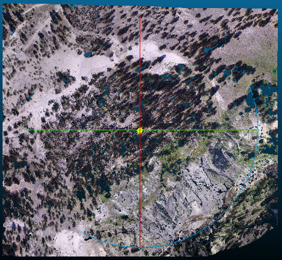
For flat to generally undulating areas, the results have been amazing I've extracted bare earth model, that is good enough for my project (Figure 1).
Area looking black are actually tree shadows and not trees.

- Figure 1.jpg (92.81 KiB) Viewed 123348 times
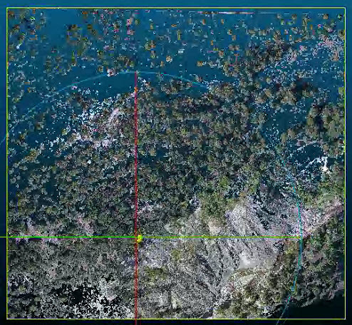
However, for relatively steep slopes with thick tree cover and/or surface erosion debris, there're certain points which were classified into vegetation but actually correspond to earth/ground, e.g. For one such area in the project site, post classification results are shown in Figure 3 (Bare Earth)

- Figure 3.jpg (182.14 KiB) Viewed 123348 times
and Figure 4 (Vegetation).

- Figure 4.jpg (125.43 KiB) Viewed 123348 times
In Figure 4 you can see that there points (white/brown) that should've been classified as bare-earth but weren't. Could you guys suggest what is the pblm here? The scale for my classifier varies from 0.10 to 25 with a step of 0.20. I've used upper limit to be 25 because there're certain houses on project site that are close to 25m in length.
Also, how can I save the classified point cloud so that I could use that classification later. I've saved the classified point cloud as .bin and .las/laz formats. .bin file would not open afterwards, and .las/laz file doesn't show classification (or scalar fields) once saved and reopened.
Is there a way to classify river/stream water as a separate entity? So far, it gets classified into vegetation. DO I need to train another classifier for that?
Regards,
Umair
Re: qCANUPO (classifier files, etc.)
Posted: Fri Oct 21, 2016 1:41 am
by uasghar
Daniel and Dimitri,
I've been able to improve my classifier so that now I over 90% of the ground points in the toe part (as mentioned in previous comment) get classified into bare earth. I should thank you guys again for creating something like this and making it opensource.
The next step for me is to fill the holes left by tress and buildings in my model after classification. Could you please point me towards any opensource software/plugin for that? I'll really appreciate an earliest response.
Regards,
Umair.
Re: qCANUPO (classifier files, etc.)
Posted: Fri Oct 21, 2016 6:19 am
by daniel
Well, I don't know any magical solution to this.
You can try with the rasterize tool to fill in the holes ('interpolate' empty values) but it only works with 2.5D clouds, and it will resample the whole cloud regularly.
You could also create a mesh and then sample points on this mesh. But once again you'll get a resampled cloud and the shapes may be locally modified. You can even test the qCSF plugin and see if the 'drape' it generates suits your needs (it should more or less correspond to the bare earth - and it can be exported as a mesh).
Re: qCANUPO (classifier files, etc.)
Posted: Wed Dec 14, 2016 4:13 am
by uasghar
wpqjbzwm wrote:Hi, @uasghar.
For bare-earth extraction, there is another option. You may try new CSF plugin. (see
http://www.danielgm.net/cc/forum/viewto ... =21&t=1724)
Hope to see your comparison of qCANUPO and CSF. I guess qCANUPO should be better, because it uses more information to classify ground and non-ground points. But CSF will be easier to use.
I tested your plugin today on Photogrammetrically point cloud consisting of over 80 million points, and I must thank you that it worked better than my expectations, for very irregular surfaces (e.g. erosion gullies with very sharp spikes) it CSF performed very well. However, the settings I used were 0.2, 800, and 0.5 (with both steep slope options checked). I actually moved step by step from cloth resolution of 1 to 0.1 while keeping all other values constant, and until 0.2 my bare-earth model constantly improved. However, when I changed from 0.2 to 0.1, my bare-earth model had less points (especially in areas with erosion gullies), what I got for 0.2. Do you know if there's any specific reason behind that?
and thanks again for your plugin.
Regards,
Umair.