Page 2 of 2
Re: Comparing clouds from cave survey - mask unwanted points
Posted: Thu Sep 10, 2015 9:47 am
by daniel
For this particular application I'd like to keep the original FARO files (as there are more info in there ;). I'll register them myself (at least if there are enough non-changing overlapping parts?).
Re: Comparing clouds from cave survey - mask unwanted points
Posted: Thu Sep 10, 2015 12:25 pm
by nickruss
Daniel,
You can download before and after scans from roughly the same setup position from
http://we.tl/W1fIbVP8qY. These are the raw Faro X130 scans, but there are plenty of overlaps to allow a good registration (C2C works well in all our software). A graphic showing the main changes between the visits is shown below.
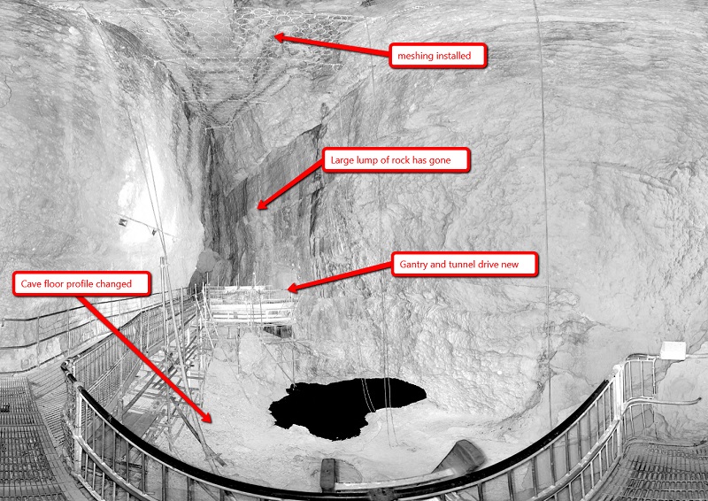
- cave_after.jpg (225.3 KiB) Viewed 12867 times
Kind regards,
Nick
Re: Comparing clouds from cave survey - mask unwanted points
Posted: Thu Sep 10, 2015 1:45 pm
by daniel
Thanks, I've downloaded the files (you can remove the link if you want).
Re: Comparing clouds from cave survey - mask unwanted points
Posted: Thu Sep 17, 2015 6:56 pm
by daniel
Okay, good news, I've finally had the time to make this work!
Now, when you import a Faro or PTX file, you'll get a sensor associated to each cloud with the right parameters. Simply select the two clouds you want to compare and start the Distances computation tool:
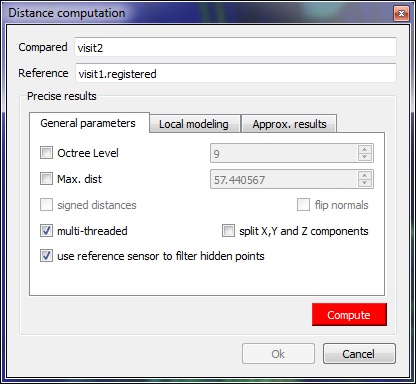
- cc_comparison_dialog_visibility_option.jpg (45.21 KiB) Viewed 12858 times
There's a new option in the Distances computation dialog: 'use reference sensor to filter hidden points' (only available is your reference is a cloud and it has an associated sensor of course). Enable it and CC will automatically compute the depth buffer and use it to filter out the points that are 'hidden'.
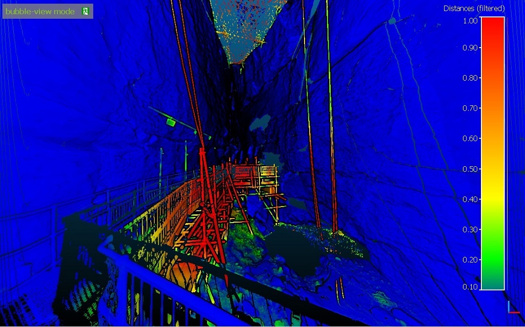
Here are the 'standard' distances computed on your example:
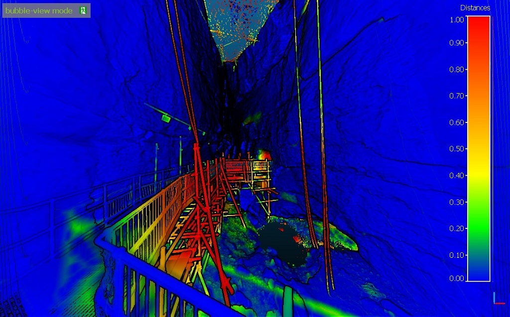
- cc_dist_raw.jpg (208.82 KiB) Viewed 12858 times
And here is what you'll get with the 'sensor filtering' option:
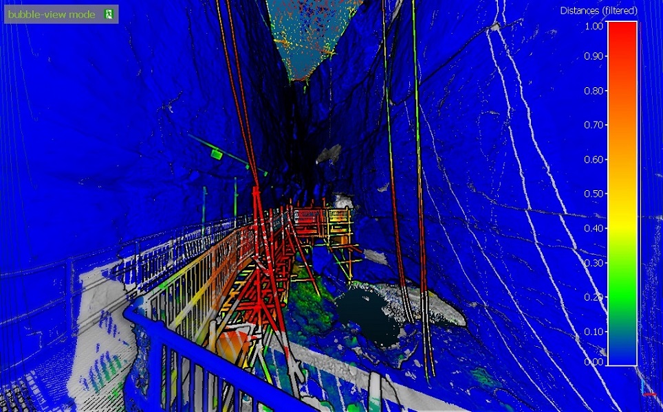
- cc_dist_filtered.jpg (254.84 KiB) Viewed 12858 times
You can see how the points that were hidden by the rail or even the ropes are now grayed out. And the bump is clearly visible in the background.
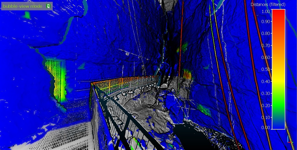
You can hide the gray points to get a clearer rendering by disabling the 'Show NaN values in gray' option in the SF properties.
- cc_dist_filtered_no_nan.jpg (215.15 KiB) Viewed 12858 times
And of course you can do the computation the other way around (but I'm not sure it's very interesting):
- cc_dist_filtered_no_nan_inverse.jpg (232.28 KiB) Viewed 12858 times
I've updated the online beta version (2.6.2.beta).
P.S.: when computing distances on big clouds like this, it's better to set a 'max distance' (like 1 or 2 meters) so as to avoid losing a lot of time (in this case the points which are farther will have this max distance instead).
Re: Comparing clouds from cave survey - mask unwanted points
Posted: Thu Sep 17, 2015 7:02 pm
by daniel
And I'll use the same thread to present a very similar tool: 'Edit > Sensors > TLS/GBL > Compute points visibility (with depth buffer)'
This tool can be used to classify any point cloud in terms of visibility (relatively to a sensor). Simply select the sensor and then CC will let you choose any of the loaded cloud. The output is:
- 0 = visible (blue)
- 1 = hidden (green)
- 2 = out of range (orange)
- 3 = out of field of view (red)
Here's the result on the same cloud as previously:
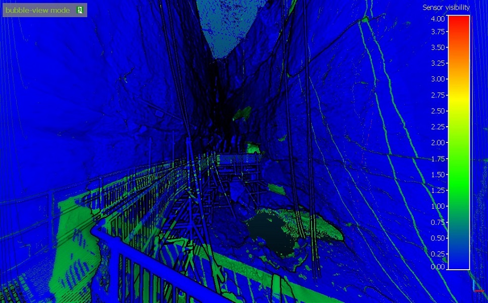
- cc_sensor_visibility.jpg (213.75 KiB) Viewed 12858 times
Re: Comparing clouds from cave survey - mask unwanted points
Posted: Fri Sep 25, 2015 8:46 am
by nickruss
Hi Daniel,
Thanks very much for adding this enhanced functionality to CC. I can confirm that with the Faro scans, we have successfully undertaken this process with good results.
Now we will try it with scans from our Topcon scanner, exported as .ptx
Best wishes,
Nick
Re: Comparing clouds from cave survey - mask unwanted points
Posted: Fri Sep 25, 2015 9:31 am
by daniel
Thanks for the feedback. Don't hesitate to report any issue with PTX files.